Hamblin Mountain
(Lake Mead NRA)

Hamblin Mountain - The trailhead for this moderately strenuous hike is located just beyond mile marker 18 on Northshore Road, about 15 miles from the intersection with Lake Mead Boulevard. The route follows a series of washes to a small ridge, crosses the ridge and follows another drainage to the base of the peak. The top section of the peak is jagged with some exposure, but the views of Lake Mead are fantastic. Another very colorful canyon offers the option of a partial loop hike. Total distance is between 6 and 7 miles with a vertical gain of 1440 feet.
Harris Peak
(Spring Mountains NRA)
Harris Peak - The shortest peak hike out of Kyle Canyon at 5 miles, this out-and-back hike requires plenty of stamina. The strenuous hike almost immediately begins at a steep rate climbing up Rainbow Canyon to the Harris Saddle. (This trail is temporarily closed due to the 2013 Fire.) This section is all on trail, but the remaining part of the hike is a route marked by ribbons that require some navigational skills to get through all the vegetation and other obstacles. Total elevation gain is 2300 feet, and the view at the summit makes the steep climb worth every ache and pain.
Hidden Canyon
(Red Rock Canyon NCA)
Hidden Canyon - This moderately strenuous loop hike within the boundary of Red Rock Canyon NCA begins at the Cliff Shadows Park on Cheyenne Avenue west of CC215. The route loops around to the base of Summerlin Peak and continues along a ridge into the mouth of Hidden Canyon. The trail heads back out on the other side of the canyon and makes its way over to the base of Eagle Peak ridge. Here the 7 mile hike finishes by looping back to the approach trail. There is 1150 feet of elevation gain.
Hidden Forest
(Desert National Wildlife Refuge)
Hidden Forest - To access this hike, drive north of Las Vegas on Highway 95, turn right on Corn Creek Road to the Desert National Wildlife Refuge Visitor Center, turn left on the poorly maintained Alamo Road and drive about 15 miles to the signed road that leads to the Hidden Forest trailhead. The 11 mile out-and-back moderately strenuous hike starts in Dead Man Canyon. The desert vegetation gradually becomes more lush and about 5 miles later becomes a high mountain ponderosa pine forest. A Forest Service cabin at the turn around point has been refurbished for shelter use. Total elevation gain is about 2000 feet, but the climb rate is quite gradual. The most difficult part is hiking through gravel in the main drainage.
Hilltop Loop
(Red Rock Canyon NCA)
Hilltop Loop - This is an easy to moderate 3 mile loop around the upper contours of a hill that offers views of Charleston Peak and surrounding mountainous landscape. It begins and ends at the Twilight Trailhead located 9 miles up Kyle Canyon Road and has 500 feet of elevation gain.
Historic Railroad Tunnels, Hoover Dam, and O'Callaghan-Tillman Bridge
(Lake Mead NRA)
Historic Railroad Tunnels - The starting point for the hike is located at the Alan Bible Visitor Center near the intersection of Highways 93 (U.S.) and 166 (Nevada.) Either the upper parking lot at the center or the lower lot a short distance toward the lake may be used. The trail passes through five tunnels next to Lake Mead built for the rail line used during construction of Hoover Dam. A newly opened lower section continues downward and ends on the top floor of the parking garage at the dam. Another trail junctions with this trail to take visitors to the walkway that crosses the Hoover Dam Bypass bridge. Total out-and-back distances are 5 miles (easy to moderate) if stopping at the fifth tunnel or 7 miles (moderate) if going to the dam. Add another 2 miles (moderately strenuous) if you are going up to the bridge. Elevation change happens only at the dam and bridge.
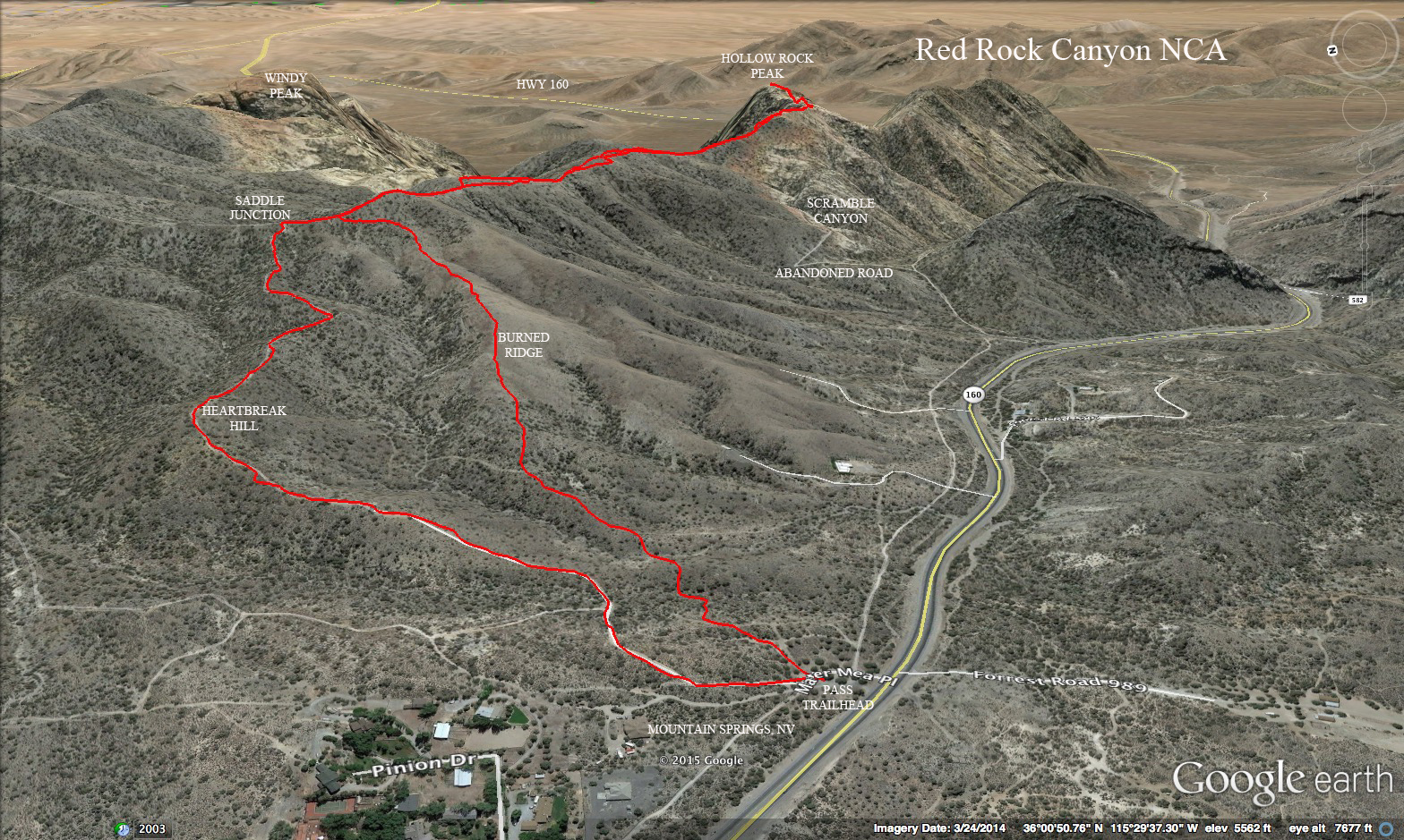
Hollow Rock Peak
(Red Rock Canyon NCA)

Hollow Rock Peak - To access the hike, take Highway 160 to Mountain Springs Summit Pass Trailhead. Start on a gravel road that climbs for 3/4 mile to pass a radio relay tower it turns into a trail that takes you to a saddle. Turn right and follow the trail which ascends and descends several times, the last time being the most change in elevation with steep rock scrambling before reaching the furthest point. Along the way, see the limestone change to sandstone beneath your feet. The view of Grapevine Canyon is to the left and Mt. Potosi to the right. The out-and-back moderately strenuous hike is 5 miles with a net elevation gain of 1900 feet. One option on the return is to follow the burned out ridge down and cross back to the parking on a utility road that parallels the highway. Another option is to drop into a sandstone drainage to the south at the point where the sandstone and limestone connect. Either the wash or an adjacent abandoned dirt road will take the hiker down to a service road that parallels the highway back to the trailhead.
Route Descending Burned Ridge
Route Descending Through Sandstone Wash
Route Descending on Abandoned Road
Hoodoo Forest Loop
(Desert National Wildlife Refuge)
Hoodoo Forest Loop - This trail begins at the Wagon Wheel Trailhead at the end of Cow Camp Road in the Desert National Wildlife Refuge. High clearance vehicles are required. The loop is 5 miles and is labeled strenuous due to a formidable climb over difficult terrain to a ridge at around 7000 feet in elevation. The rewards of the climb come as hikers make their way down a somewhat gentle ridge passing the Hoodoo Forest and other interesting rock formations. There are 1600 feet of elevation gain within the hike.
Hoover Dam Bridge Peak
(Lake Mead NRA)
Hoover Dam Bridge Peak - This hike uses the Goldstrike Canyon Trailhead found by turning right at the bottom of the Hoover Dam exit off of Highway 93 from Boulder City. The route climbs up to the ridge on the left and, with strenuous effort, follows the rocky ridgeline to the last peak. The return drops into Goldstrike Canyon and follows the wash back to the cars. The strenuous hike is 5 miles with 1750 feet of elevation gain.
Horse Thief Canyon
(Lake Mead NRA)
Horse Thief Canyon - This moderate canyon can be accessed from the White Rock Canyon Trailhead located 4 miles south on Highway 93 from the Hoover Dam bridge. A rough high clearance road leading into the hills from the parking lot ends at a canyon dry fall where the hike begins. To gain access to the canyon, climb up and around on the left side. The short interesting canyon has cottonwood trees growing since there is often water trickling through it. The turnaround point is at the "hanging tree" just before a large dry fall blocks your progress. The out and back hike is only 2.5 miles with 700 feet of elevation gain. This canyon is also the approach to the Wilson Peak climb, a challenging very strenuous climb up to the highest peak of the range.
 Hamblin Mountain - The trailhead for this moderately strenuous hike is located just beyond mile marker 18 on Northshore Road, about 15 miles from the intersection with Lake Mead Boulevard. The route follows a series of washes to a small ridge, crosses the ridge and follows another drainage to the base of the peak. The top section of the peak is jagged with some exposure, but the views of Lake Mead are fantastic. Another very colorful canyon offers the option of a partial loop hike. Total distance is between 6 and 7 miles with a vertical gain of 1440 feet.