Macks Canyon Road
(Spring Mountains NRA)
(Spring Mountains NRA)

Mack's Canyon Road - The gravel road that goes into Mack's Canyon is located on Lee Canyon Road a short distance past the Sawmill equestrian and picnic area. There is a pull-off area by the road to park vehicles. The road itself is 5 miles long going into the canyon. Since this is an out-and-back hike, you can go whatever distance is comfortable before turning around. Depending on the distance hiked, the road is easy to moderate in rating. The high point of the road is the Sisters Spur Road (2 miles in) that is not vehicle friendly. After this point, the road drops slowly down into Mack's Canyon. This is not a good hike to do on weekends in the summer due to the fact that this is a popular camping area and traffic on the dusty road is heavier. The out and back hike from the Sawmill Trailhead to the Sisters Spur Road is 4.5 miles with 850 feet of elevation gain.


Macks Peak
(Springs Mountains NRA)


Mary Jane Falls
(Spring Mountains NRA)
(Spring Mountains NRA)

Mary Jane Falls - To reach the trailhead, take Kyle Canyon Road to Echo Drive, turn right for about 1/2 mile, and turn left on the signed gravel road passing the Trail Canyon Trailhead and drive further to the next parking area. The trail starts off with a moderate climb as it heads to the northwest. After 3/4 mile, the trail turns sharply to the right and climbs more steeply on a series of switchbacks. Near the falls, there are several sections of rock steps. This easy to moderate hike is best done in the early spring when larger volumes of water are cascading over the cliffs above. This out-and-back hike is 3 miles long with a vertical gain of 920 feet. Hikers can continue around the cliff wall at the falls on a trail that leads to a large cave with a nice view of Kyle Canyon.


McCullough Hills Trail
(Sloan Canyon NCA)


McFarland Peak
(Spring Mountains NRA)


North Ridge Approach


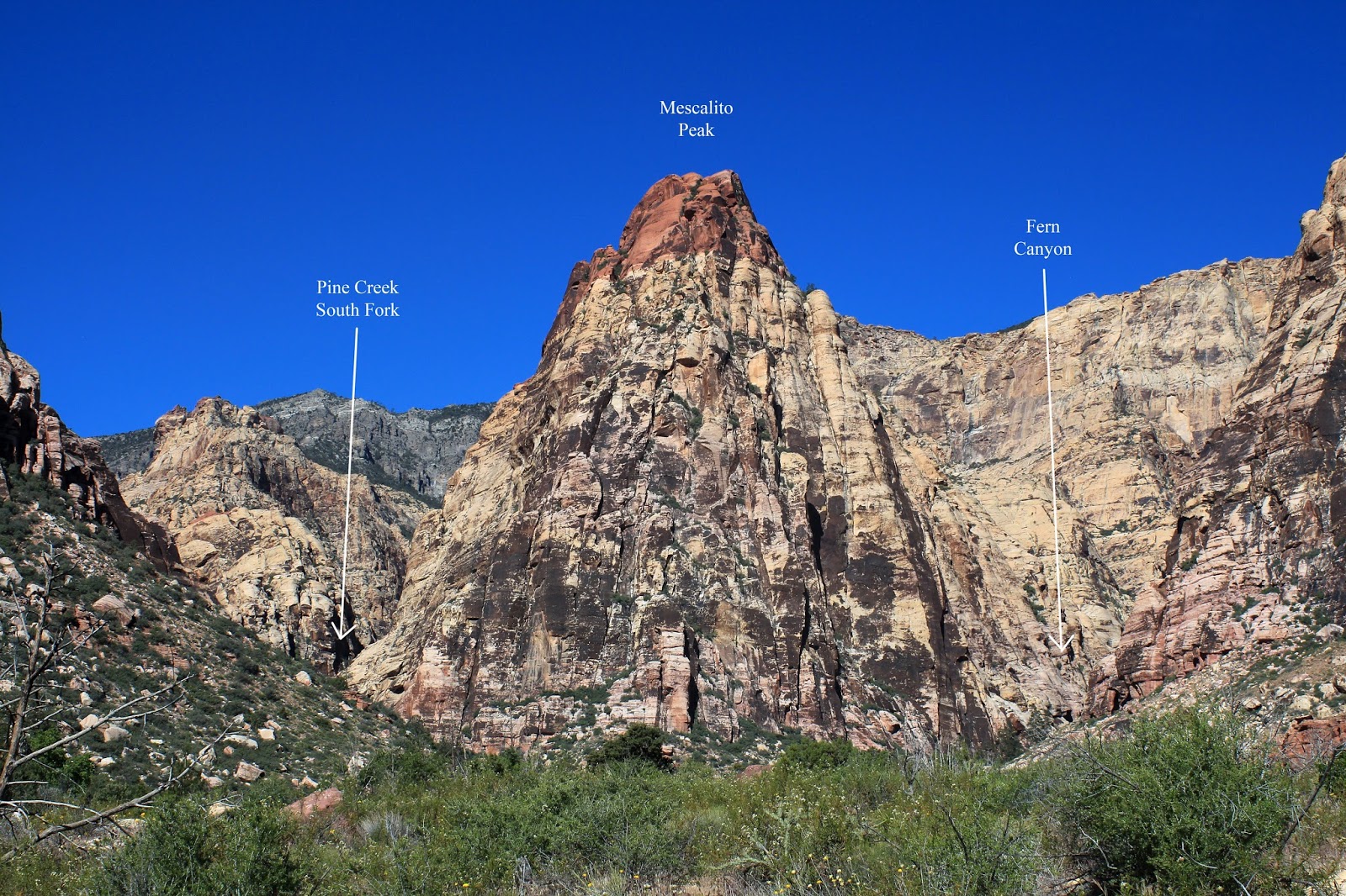
Mescalito Peak
(Red Rock Canyon NCA)


Middle Deer Creek Canyon Trail
(U.S. Forest Service)


Moenkopi Loop
(Red Rock Canyon NCA)
(Red Rock Canyon NCA)

Moenkopi Loop - This short easy hike in Red Rock begins at the Visitor Center, which has a direct exit back to Highway 159 without driving the scenic loop. The trail is currently accessed by going west in front of the new building through a small picnic area. After hiking to the bottom of the hill and turning right, the trail will turn right at a junction after a few yards. Turn left at a signed junction about 1/4 mile from the first turn and follow the trail north through the desert for about 3/4 miles. At that point, follow the trail which bends left and climbs a small ridge. Descend on the other side, turning left and following a short section of the Grand Circle Trail back to the Visitor Center. Total distance is slightly more than 2 miles with less than 200 feet of elevation gain.

Mormon Camp Loop
(Spring Mountains NRA)

Mormon Camp Trail - The starting point for this moderate hike is a parking area off a gravel road on the left of Highway 158 about one mile north of the Deer Creek picnic area. The loop hike consists of some gravel road and trails that circle into the Mormon girls' summer camp. The trail (labeled Fire Exit) has one steep drop on the descent that is aided by a rope tied to a tree. Total distance is about 5.5 miles with 1100 feet of elevation gain. This hike should only be done before early June or after Labor Day because it is private property.


Mother Loop
(Bootleg Canyon Park, Boulder City)
West Leg / Cut Across / Caldera / Mother


Red & Black Tr / Caldera / Mother


Mother Trail O&B


Mountain Springs Loop
(Mountain Springs, NV)


Mountain Springs Peak
(Red Rock Canyon NCA)
(Red Rock Canyon NCA)

Mountain Springs Peak - To access the route to the limestone peak overlooking Red Rock and Cottonwood Valley, take Highway 160 to Mountain Springs Summit Pass Trailhead. The moderately strenuous route first follows a gravel road to a radio relay tower and then a trail to a ridge, then turns left. Another left at a trail fork continues to the limestone ridge behind the southern part of the escarpment. The trail hugs the front edge of the ridge and winds to the east, climbing the peak above Mud Springs Canyon. The views from the top are sensational. Total elevation gain is 1,300 feet. To return to the starting point, either reverse the direction for a total distance of 5 miles or turn the hike into a loop of 7 miles by first following a ridge or wash to the west and turning left on Mountain Springs Trail, passing the two main Mountain Springs to the starting point.
Route as an Out-n-Back


Route as a Loop


Mount Charleston
(Spring Mountains NRA)
(Spring Mountains NRA)

Mount Charleston - Two strenuous routes lead to the highest peak in southern Nevada. The South Loop Trail starts near the Cathedral Rock Picnic Area at the end of Kyle Canyon Road (Hwy 157), climbs up to the junction with the Harris Springs Trail (the saddle), then turns right across the top of the south ridge, passing a large meadow area and the site of a 1955 plane crash before making a steep climb to the summit. One-way distance is 8.75 miles. The North Loop Trail starts at Highway 158 and is 11 miles long, but it can be shortened to 8.25 miles by using Trail Canyon Trail out of Kyle Canyon. Either of these trails can be done as an out-and-back, or the peak can be hiked as a point-to-point (South Loop and North Loop) hike using Trail Canyon for a total of 17 miles and 5500 feet of gross elevation gain.


South Loop Approach

Mud Mack Loop
(Spring Mountains NRA)

Clockwise


Mud Springs
(Spring Mountains NRA)
(Spring Mountains NRA)

Mud Springs - The shortest starting point for this moderate 5 mile out-and-back hike (with 1200 feet of elevation gain) is located about three miles along Mack's Canyon Road, on the north side of Highway 156 just west of the Sawmill Picnic Area. This hike follows a well-maintained trail above three natural springs that are a source of water for wildlife, including a herd of elk that roam the northern sections of the Spring Mountains. The terrain along the trail undulates within the 7500 to 7700 foot elevation range. Mud Springs can also be accessed from the Sawmill Trailhead via an 18 mile loop. This loop can be divided into two loops (upper and lower) easily. And, the 5 mile route can also be extended by one mile using a different starting point. With more distance, the hike becomes moderately strenuous.
Out and Back (6 miles) using the upper trailhead.


Lower Mud Springs Loop using upper trailhead.


Muffins and Skull Canyon
(Red Rock Canyon NCA - North Blue Diamond Hills)

Muffins & Skull Canyon - Begin the hike at the gravel Cowboy Trails parking lot located about 0.7 miles west of the Red Rock entrance. The partial loop hike heads toward the mouth of Skull Canyon on Blue Diamond Hill. The trail turns back to the left at a junction and climbs the north ridge to the unusual rock formations known as the Muffins. After about one mile hiking across open terrain up the ridge you cross the trail descending into Skull Canyon. Turn right and follow the trail to the starting point. This moderate partial loop hike is about 5.5 miles long with 1300 feet of gain. The Muffins hike can also be used in combination with other routes in the North Blue Diamond Hills.


Mummy's Nose
(Spring Mountains NRA)


Mummy Springs
(Spring Mountains NRA)
(Spring Mountains NRA)

Mummy Springs - This moderate to moderately strenuous hike utilizes the North Loop Trail which begins on Highway 158. The trail climbs up past a meadow and 12 switchbacks for a total elevation gain of 1400 feet. Turning to the right on the North Loop Trail, the hike begins a slow descent for 1/2 mile to the site of "Raintree." A spur trail for the springs bears to the right again for a somewhat steeper descent for 1/3 mile ending below a 10-foot rock wall area from which the springs beneath Mummy Mountain flow. The return hike can be done as an out-and-back, or by using either Wild Horse Canyon or Wild Horse Ridge. Either way, the hike is between 5.5 and 6 miles total. Another option is to make the hike a more strenuous loop by starting up along Deer Creek to the old resort cabins and climbing a ridge to the Mummy's Toe Trail just beyond the spring and returning on North Loop Trail, a total of 6 miles.
Route Up Deer Creek Trail & Down Wild Horse Canyon


Route Up Deer Creek Trail & Down North Loop Trail


Mummy's Toe
(Spring Mountains NRA)

Route Up and Back via Deer Creek Trail


Route Up Deer Creek and Down North Loop


Mummy's Tummy
(Spring Mountains NRA)


