Railroad Pass Mountain Loop
(Bootleg Canyon Park, Boulder City)


Rainbow Canyon
(Lake Mead NRA)


Rainbow Gardens
(Lake Mead NRA)

Rainbow Gardens - The starting point for this easy to moderate hike can be found by traveling east on Lake Mead Boulevard to its intersection with Northshore Road, then turning right on Northshore Road for about one mile to a large pullout on the right side of the road. The hike begins in Lava Butte Wash southwest of the pullout. The route follows the wash to a ridge, then follows the faint remains of a road across the top before dropping into another wash that turns into a slot canyon with 30-foot high walls and some amazing colored patterns. Round trip distance for the hike is 5 miles with 300 feet of vertical gain. The hike can be extended by one mile by entering Lake Las Vegas property on a dirt road and reaching a small arm of the lake.


Rainbow Loop
(Spring Mountains NRA)

Rainbow Loop - This partial loop moderately strenuous hike begins at the Fletcher Canyon trailhead parking area across from Fletcher Canyon on Kyle Canyon Road. Cross the bridge over the wash and turn to the right. The hike leads up the partially paved trail parallel to the road passing two campgrounds and the lower portion of the community of Rainbow. The trail then turns left up to the South Loop Trail and follows it for about 1/2 mile. Turning left at a switchback on the South Loop, the Rainbow Loop trail climbs up to a ridge on the remnants of a road where there are great views of the Kyle Canyon area. The trail then turns off of the dirt road to the right onto a small soft and wooded path which leads back down through Rainbow cabins and houses. At the bottom of the hill, turn right to return on the same trail leading back down by the wash. Total distance for the hike is 5.65 miles with 1170 feet of elevation gain. (The small wooded path still needs to be reconstructed since the fire of 2013.)


Rainbow Ridge
(Lake Mead NRA)


Raintree
(Spring Mountains NRA)

Raintree - This moderate to moderately strenuous hike utilizes either the North Loop Trail from Highway 158 or Trail Canyon and the North Loop from Kyle Canyon to the old bristlecone tree. Raintree is located on a saddle at the base of Mummy's Toe Mountain. The Highway 158 return can be done by out-and-back on the North Loop or by utilizing the Wild Horse Canyon or Ridge Trails on reaching the meadow area after retracing the switchbacks. These routes are less than 6 miles with an elevation gain of 1400 feet. From the Trail Canyon side of Raintree, the out and back hike is 7 miles with 2400 feet of gain. But the views from the trail on this side make the extra effort worthwhile.


Up North Loop /Down Wild Horse Ridge


Up North Loop / Down Wild Horse Canyon


Raintree via Trail Canyon


Rattlesnake Canyon
(Red Rock Canyon NCA)


Rattlesnake Trail
(Red Rock Canyon NCA)


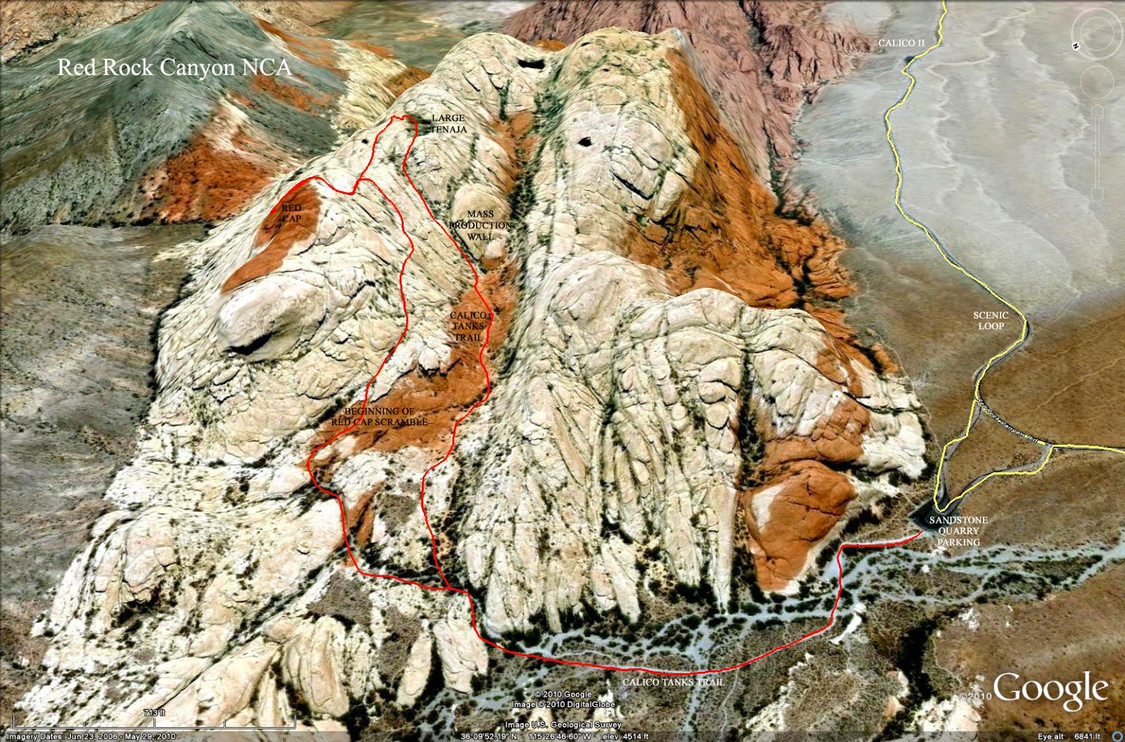
Red Cap (aka Turtlehead Junior)
(Red Rock Canyon NCA)

Red Cap - Also known as Turtlehead Junior, this scramble route is accessed from Sandstone Quarry inside the Red Rock scenic loop. There are two popular routes that can be used for the climb - one on the front and the other on the back side. The peak, which has a red sandstone mantle, is the highest point in the Calico Hills. This strenuous hike is short at about 3 miles total distance, but half of it involves significant scrambling on the sandstone slabs above the canyon serving the Calico Tanks Trail. There will be plenty of obstacles to get over or around and some great climbing requiring use of hands. Visit the location of four natural tanks which often hold water on the top of the ridge following the descent from the summit. The descent then generally goes along a climbing route known as Mass Production Wall and down the Calico Tanks Trail. Total gain for the hike is around 900 feet. A more difficult 5-mile option is to start at Calico II Overlook, hike to Sandstone Quarry and the peak, turn left on the Calico Tanks Trail after the descent past Mass Production Wall, then rock scramble down to Calico II from the end of Calico Tanks. Routes on Red Cap can vary from moderate to strenuous scrambling.
Front Ascent with Descent at Mass Production Wall
Front Ascent with Descent Down Back


Route Up via Dragon Canyon & Down via Ash Canyon on Back


Red Cap/Calico II Peak Combined


Red Cap / Calico II Loop
(Red Rock Canyon NCA)


Red Mountain
(Boulder City)

Red Mountain (Boulder City) - The River Mountain Trail trailhead, located adjacent to St. Jude Children's Ranch on Highway 93 in Boulder City, is the starting point for this hike. There are several approach trails that can be used to reach the observation point at the peak. The normal approach is an out-and-back on the city trail that climbs through the canyon separating Red and Black Mountains, going from the top of the saddle to the peak. Other approaches involve using the bike trails going into Bootleg Canyon Park and climbing to the peak from the southwest. These routes can be shorter and have better scenery. The bike trails also have a higher difficulty rating. Either way, the total distance is between 5 and 6 miles with 1225 feet of elevation gain. You can also add a trek to Black Mountain Overlook to the hike, bringing the total distance to 7 miles. Routes can vary between moderate to strenuous on the bike trails.
Red & Black Loop


Bootleg Loop with Red & Black


Red Rock Summit
(Red Rock Canyon NCA)

Red Rock Summit - Usually done as a training hike for the Grand Canyon or other strenuous destinations, Red Rock Summit is the highest point on Rocky Gap Road between Willow Springs Picnic Area and Lovell Canyon. The entire hike is conducted on dirt & gravel road, with a total distance of 9.5 miles and an elevation gain of 2000 feet. The broad canyon in which the road travels is surrounded by unique views of the surrounding mountains.


Red Springs Loop
(Red Rock Canyon NCA)

Red Springs Loop - The hike begins at the Red Springs picnic area located in Calico Basin. The trail follows along the east side of the Calico Hills to the base of a notch named Angel Pass. Climbing the notch involves significant rock scrambling, but the view from the top is worth it. On the descent, you will pass a boat shaped rock with a carving of an angel, probably attributed to a rock climbing artist. The return on the moderate loop is in Calico Canyon as it follows around the south end of the Calico Hills. Total distance is 3.75 miles with 600 feet of elevation gain.


Redstone Discovery
(Lake Mead NRA)


River Mountain
(Lake Mead NRA)

Out and back from River Mountain Trailhead


Partial Loop using Inner Caldera Loop


River Mountains Trail
(Lake Mead NRA - Boulder City)

River Mountains Trail - This moderate hike connects the area near the Black Mountain trail head in Boulder City to the start of the Historic Railroad Tunnels hike at the Alan Bible Visitor Center. Although longer versions can be done, the best route, an out-and-back hike of 6.6 miles, starts at a parking lot near the junction of Pacifica Way and Highway 93 about halfway down the long grade to the lake. The trail follows another section of the abandoned rail line, going through a rock cut and over some dikes crossing a few drainages. There is an elevation gain of 240 feet on the return segment. There is absolutely no shade on this hike, so be prepared with extra water. The complete trail is a loop around the River Mountains with a distance of around 30 miles.
Route from River Mountain Trailhead to Railroad Pass Casino


Robbers' Roost to Stepladder
(Spring Mountains NRA)


Rocky Gorge
(U.S. National Forest)

Rocky Gorge Loop


Lower Rocky Gorge Loop


Rubber Ducky Yucca
(Red Rock Canyon NCA)


Rufus Cove
(Lake Mead NRA)


