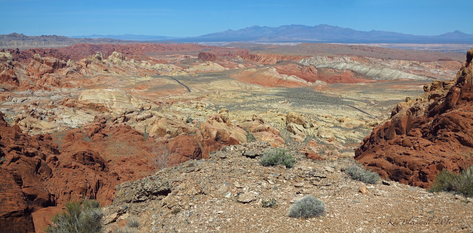
7-Up
(Valley of Fire)
Seven-Up
- This Valley of Fire hike is a strenuous scramble that begins at the
Mouse's Tank Trailhead. It follows along the Five Mesas hike after
adding two particular difficult mesa scrambles in the beginning. At the
end of the hike, you will have summited seven different mesas
(plateaus) covered with dolomite limestone that rise above the colorful
sandstone below. This hike is 6 miles with 2100 feet elevation gain.
6000 Lee Canyon Loop
(U.S. National Forest)
6000 Lee Canyon Loop - The trailhead for this hike is located about 9 miles up Lee Canyon Road at the 6000 Feet elevation road sign. The route finds a trail that heads up into the hills to the right. The small trail feeds into the Rocky Gorge wash. After climbing up through the little gorge, the route bushwhacks up the hill to the left and connects with the Rocky Gorge Trail to descend to the Blue Tree Trailhead. Cross the road and drop into Lee Canyon for a hike down past Pleistocene era rock formations and burro beds. The wash has to be navigated through deep gulleys then a small trail takes you back over to the original trailhead. The moderately strenuous loop is 7 miles with 1100 feet of elevation gain.
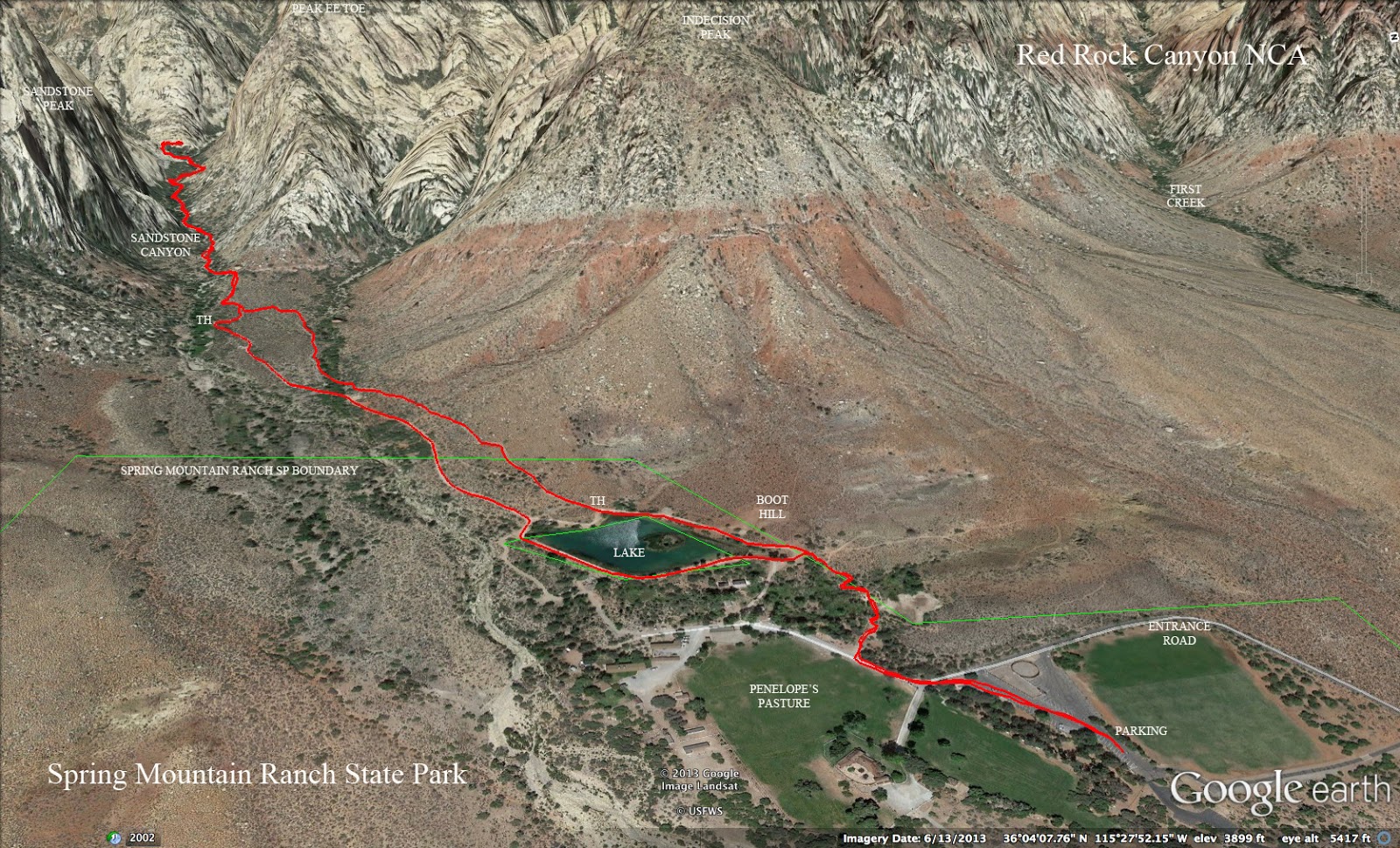
Sandstone Canyon
(Spring Mountain Ranch State Park)
Sandstone Canyon - To access this canyon, enter the Spring Mountain Ranch State Park on Highway 159. Hike past the lake and toward the escarpment to find a trail that leads into the canyon beyond. There is a lot of moderate scrambling and beautiful rock formations within the sandstone walls. A normal stopping place is where the canyon forks in two clear directions. The out and back hike to this point is 4 miles with 900 feet of elevation gain.
Sandstone Quarry / Keystone Thrust Loop
(Red Rock Canyon NCA)
Sandstone Quarry / Keystone Thrust Loop - This moderate to moderately strenuous partial loop hike of 7 miles begins at the Sandstone Quarry turnout on the Red Rock Canyon scenic loop. Using the Grand Circle Trail, the route crosses the desert to the White Rock Trailhead then climbs up to the Keystone Thrust fault. Next, the route descends the wash below the rare geological fault and intersects with the Grand Circle for the return. There is 1350 feet of elevation gain.
Sawmill Trails
(Spring Mountains NRA)

Sawmill Trails - Essentially an equestrian and picnic area, the Sawmill Trailhead is located on Lee Canyon Road about one mile before the intersection with Highway 158. Although there are several possible hiking routes, the easy to moderate loop route will make a short but steep climb onto a ridge. After a short drop on an old road, turn right onto a trail and return to the starting point in one of two ways. Total elevation gain is less than 500 feet. This route is around 3 miles in distance, however, both shorter and longer routes exist. The trails at Sawmill are color coded with yellow, green, red and blue markers. There are orange and blue markers on trails across Lee Canyon Road.
3 Mile Loop
Sawmill Wiggles Loop
(Spring Mountains NRA)
Sawmill Wiggles Loop - Starting where the Cardamine Road junctions with Lee Canyon Road at mile marker 11.6, the Sawmill Wiggles Loop ascends up that road to the Sawmill Trailhead for a break at the picnic area. Then, the moderate 5 mile hike either climbs to the ridge behind the trailhead or traverses around it and descends via the Blue Trail. A final climb up a connecting forest road brings you back to the cars. This hike has 750 feet of elevation gain.
Sea World
(Lake Mead NRA)
Sea World - This hike starts at mile marker 20.5 of Northshore Road. After a climb up the trail enjoying the incredible views offered, the hike dives into the redstone and follows a small canyon out to the area located behind the North Bowl of Fire. The route bushwhacks and follows game trails through the washes and encircles either of two small peaks in the distance. The return route follows a wash on the south side of the peaks that passes "Shamu." The strenuous hike is 12.5 miles with 2000 feet of elevation gain.
Shady Hollow / Stepladder Loop
(Spring Mountains NRA)
Shady Hollow / Stepladder Loop - This easy to moderate loop begins at the trailhead across Kyle Canyon Road from the Spring Mountains Gateway Visitor Center. Although the loop can be done in either direction, the more gradual ascent will be done on the Shady Hollow side. Leaving the trailhead furthest from the pit toilet area, take a right at the fork. Circle around Stepladder Peak above to the left, find a connecting trail that switchbacks up to the left then turn left on the trail at the top. At the saddle junction, take the trail that descends along the side of the mountain to your right. This loop is 4.5 miles with 800 feet of elevation gain. The loop can be extended to a moderate 6 miles with 1300 feet of elevation gain by following trails on up toward Robbers' Roost.
4.5 mile loop
6 mile loop
Shoreline Trail / White Owl Canyon Loop
(Lake Mead NRA)
Shoreline Trail / White Owl Canyon Loop - This is a moderate 5 mile loop that begins at the old Las Vegas Marina (no longer used) located 2.25 miles on the left from the Lake Mead NRA fee booth on East Lake Mead Parkway / Lakeshore Drive. The trail follows along what used to be the shoreline of Lake Mead but, now, is only a river. Much of the trail was underwater at one time. When it reaches the area below 33 Hole Picnic Area, the route climbs up and through White Owl Canyon and beyond until there is an old road offering access up and over to the River Mountains Trail. A left turn takes hikers back to the trailhead with an option of scrambling through Hippie Canyon near the end. There is 550 feet of elevation gain.
Showgirl Trail
(Spring Mountains NRA)
Showgirl Trail - This point to point, mostly downhill hike is 9 miles in length. It runs from the Juniper Trailhead on Lucky Strike Road off of Deer Creek Road all the way to a trailhead only 14 miles up Kyle Canyon Road on the left side. (This trailhead has recently been opened to parking.) There is one section of the original trail that has not been maintained therefore, the trail described here contains a "go around" that avoids the ridge route. Follow the trail from the upper trailhead taking the trail that descends down the hill to the right forward direction. At the bottom (Telephone Canyon Road), connect with the Tin Can Alley Trail until you are able to cross the dirt road to return to the Showgirl Trail. Now, continue following this trail down through desert terrain to the lower trailhead. The moderate to moderately strenuous hike only has 300 feet of elevation gain but, also has a loss of 2500 feet.
Signature Rock
(Lake Mead NRA)
Signature Rock - The rock with inscribed names is interesting but only a good turnaround point. This colorful hike has many points of interest including petroglyphs, the old Arrowhead Road, rock formations, and some fun moderate scrambling. The trailhead is the pullout on Northshore Road at mile marker 18. The moderately strenuous loop hike is 9 miles with 1300 feet of elevation gain. However, a shorter out and back hike can be done with less difficulty.
SMYC Trail (Spring Mountain Youth Camp Trail)
(Red Rock Canyon NCA)

SMYC Trail - The SMYC Trail runs between the Lost Creek Trail on the Willow Springs spur road off of the Red Rock scenic loop and the Ice Box Canyon Trail. It can be accessed from either point as an easy to moderate out-and-back hike with a distance between 2 and 3 miles, or as a point-to-point hike of 2 miles. The trail rolls along the north end of the escarpment, crossing the main Red Rock drainage. Total elevation gain is 200 feet.
South Bowl of Fire
(Lake Mead NRA)

South Bowl of Fire - South Bowl of Fire will provide a unique setting for hiking through the stark desert north of Lake Mead. This moderate scrambling hike will feature a consolidated section of red sandstone formations that appear in stark contrast to the surrounding area. The route will include some scrambling over the sandstone. To access the hiking area, we will be hiking in from Northshore Road at mile marker 18. The trail leads up a wash for one and and a quarter miles before entering into a large pocket of red rock. There are possibilities for scrambling and exploring in the area. Elevation gain depends on the scrambles chosen.
South Loop Overlooks
(Spring Mountains NRA)

South Loop Overlooks - Park at the new South Loop trailhead parking lot at the end of Kyle Canyon Road. The out-and-back hike climbs up through a canyon with a series of switchbacks and goes along the top of the Echo Cliffs. It reaches an open ledge with a great view of Kyle Canyon after about 2.5 miles. A second overlook can be reached after a few more switchbacks at a little over 3 miles. The third overlook is only one more switchback up. Total distance for the out and back of the third switchback is 7 miles with a vertical gain of around 1500 feet. The overlooks are rated moderate to moderately strenuous.
South Peak
(Red Rock Canyon NCA)
South Peak - The trailhead to the southernmost peak in the Red Rock Canyon escarpment is located on a small 4WD high clearance dirt road that turns
north on Highway 160, west of the Late Night Trailhead parking lot. Included in the hike is a slightly higher peak rising behind South Peak. The strenuous hike includes a steep climb up and a steep wash scramble down. The partial loop is 3 miles with 2000 feet of elevation gain.
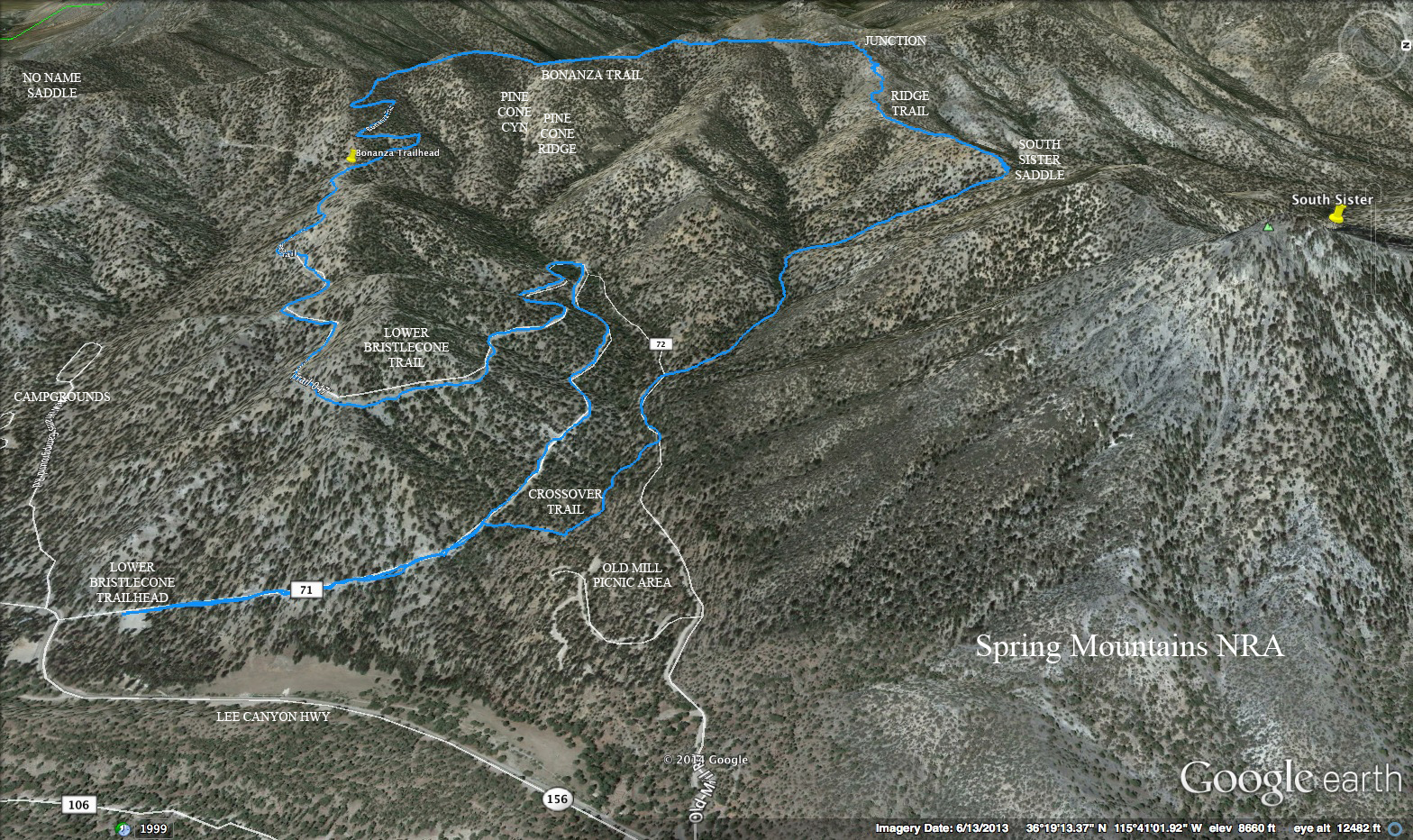
South Sister
(Spring Mountains NRA)

South Sister - The moderately strenuous hike to the summit of South Sister has some of the steepest approach areas in the Spring Mountains. At a total distance of 5 miles, this out-and-back hike has a vertical gain of 1900 feet, almost all of it in the second half of the approach. Although most of the route is on trail, little of it is classified as maintained trail. The actual peak has two outcroppings, called Big Sister and Little Sister. The sign-in book is on Big Sister, which requires climbing up a 30-foot wall through a crack, and has some exposure on the narrow, rocky top. The start of this hike is at the Lower Bristlecone Trailhead in Lee Canyon, although another approach is from the end of Mack's Canyon Road.
South Sister Saddle Loop
(Spring Mountains NRA)
South Sister Saddle Loop - The most popular way to hike a loop that includes a saddle below South Sister is by starting at the Lower Bristlecone Trailhead, hiking up this trail to the Bonanza Trail junction, taking the Bonanza Trail up approximately 2 miles to a trail turning off over the little ridge to the right and descending this ridge to the saddle. From there, the South Sister Trail is taken back to the trailhead. This moderately strenuous route is 8 miles with 1700 feet of elevation gain.
Southern Calico Scramble
(Red Rock Canyon NCA)
Southern Calico Scramble - It doesn't hurt to do this scramble with a bit of a drawl! This moderately strenuous scramble starts from the Red Springs Picnic Area and climbs up to and down from Angel Pass. Using the wash and trail routes, the hike descends down past Calico II and Calico I turnouts. Just after a scramble up through a slot, the route turns up the rocks on the left. Another climb up and over the southern part of the Calico Hills brings the hike home. The scramble is 3.5 miles with 1300 feet of elevation gain.
St. Thomas
(Lake Mead NRA)
St. Thomas - St. Thomas was a small town that got covered over by the waters of Lake Mead. As of now, this town is completely uncovered and is a very interesting place to visit. The Old St. Thomas Road is found just outside the Lake Mead NRA fee booth near Valley of Fire. The short dirt road offers a parking area where the trail begins. The easy visit is around 2.5 miles with a small elevation gain of 100 feet on the return.
Stanley B / Fletcher Canyon
(Spring Mountains NRA)

Stanley B / Fletcher Canyon - Another hybrid hike involving two adjacent canyons, this 6-mile loop with 2000 feet of gain begins at the Fletcher Canyon Trailhead. After following the main Kyle Canyon drainage for about a mile, the route proceeds up to the Stanley B mine area. Stay in the right drainage past the mine shafts continuing to the top of the canyon. A tricky route descent follows while getting into Fletcher Canyon that includes some steep terrain and some scrambling. Fletcher Canyon is then entered about one mile above Obstacle Rock, and hikers must drop through the rabbit hole made by Obstacle Rock before returning out the end of Fletcher Canyon to the cars. This hike is rated moderately strenuous.
Stanley B Mine & Springs
(Spring Mountains NRA)
Stanley B Mine & Springs - Generally done as a partial loop, this 3-mile hike starts from a gravel parking area about 2.8 miles past the Spring Mountains Gateway Visitor Center on Highway 157. The hike begins as a route through a drainage, but soon meets a well-defined trail that winds through the canyon and ends up at a junction below a large tree with a sign indicating the Leroy Mining Claim. In the left drainage, there is spring water coming out from a pipe. In the right drainage a short distance away are the old mine shafts, which are barred and quite visible. The easy to moderate hike has less than 900 feet of elevation gain.
Stepladder Peak Loop
(Spring Mountains NRA)
Stepladder Peak Loop - Beginning at the trailhead across from the Spring Mountains Gateway Visitor Center, the moderately strenuous hike uses the Shady Hollow Trail, Tin Can Alley and the Cowboy Washington Trail to take the hiker on a loop into the woods of Telephone Canyon. At a saddle, the trail heads up to the peak that rises between Kyle Canyon and Deer Creek Road. There is a small amount of rock scrambling before reaching the rocky peak. The descent is done on a bushwhacking route toward Kyle Canyon Road where it connects with the Stepladder Trail before returning to the cars. The hike is 7 miles with 1450 feet of elevation gain.
Stepladder / Showgirl Loop
(Spring Mountains NRA)
Stepladder / Showgirl Loop - This moderate 7 mile loop begins at the trailhead located across Kyle Canyon Road from the Spring Mountains Gateway Visitor Center. It starts with a climb up the Stepladder Trail then drops into Telephone Canyon. A jog to the left junctions with the Showgirl Trail. Eventually, the route loops around at the BLM fire station and returns on two more bike trails. There is 1250 feet of elevation gain.
Summerlin Peak
(Red Rock Canyon NCA)
Summerlin Peak - The out-and-back very strenuous hike to the first large peak northwest of the city begins near the west end of Cheyenne Avenue in the Cliff Shadows Equestrian Park. About 4 miles in total distance, the route starts by going around the south end of Eagle Peak until it connects with the one ridge that provides access to the top of the ridge and the peak. Very steep with hardly any trail, the route climbs over several rock formations, including one at a 30 degree angle that has some exposure. At the top of the ridge, more serious scrambling is necessary to get to the base of the short, steep ramp that goes to the summit. The view is sensational and makes up for the nearly 2000-feet vertical gain.


 Sawmill Trails - Essentially an equestrian and picnic area, the Sawmill Trailhead is located on Lee Canyon Road about one mile before the intersection with Highway 158. Although there are several possible hiking routes, the easy to moderate loop route will make a short but steep climb onto a ridge. After a short drop on an old road, turn right onto a trail and return to the starting point in one of two ways. Total elevation gain is less than 500 feet. This route is around 3 miles in distance, however, both shorter and longer routes exist. The trails at Sawmill are color coded with yellow, green, red and blue markers. There are orange and blue markers on trails across Lee Canyon Road.


 SMYC Trail - The SMYC Trail runs between the Lost Creek Trail on the Willow Springs spur road off of the Red Rock scenic loop and the Ice Box Canyon Trail. It can be accessed from either point as an easy to moderate out-and-back hike with a distance between 2 and 3 miles, or as a point-to-point hike of 2 miles. The trail rolls along the north end of the escarpment, crossing the main Red Rock drainage. Total elevation gain is 200 feet.
 South Bowl of Fire - South Bowl of Fire will provide a unique setting for hiking through the stark desert north of Lake Mead. This moderate scrambling hike will feature a consolidated section of red sandstone formations that appear in stark contrast to the surrounding area. The route will include some scrambling over the sandstone. To access the hiking area, we will be hiking in from Northshore Road at mile marker 18. The trail leads up a wash for one and and a quarter miles before entering into a large pocket of red rock. There are possibilities for scrambling and exploring in the area. Elevation gain depends on the scrambles chosen.


 South Loop Overlooks - Park at the new South Loop trailhead parking lot at the end of Kyle Canyon Road. The out-and-back hike climbs up through a canyon with a series of switchbacks and goes along the top of the Echo Cliffs. It reaches an open ledge with a great view of Kyle Canyon after about 2.5 miles. A second overlook can be reached after a few more switchbacks at a little over 3 miles. The third overlook is only one more switchback up. Total distance for the out and back of the third switchback is 7 miles with a vertical gain of around 1500 feet. The overlooks are rated moderate to moderately strenuous.


 South Sister - The moderately strenuous hike to the summit of South Sister has some of the steepest approach areas in the Spring Mountains. At a total distance of 5 miles, this out-and-back hike has a vertical gain of 1900 feet, almost all of it in the second half of the approach. Although most of the route is on trail, little of it is classified as maintained trail. The actual peak has two outcroppings, called Big Sister and Little Sister. The sign-in book is on Big Sister, which requires climbing up a 30-foot wall through a crack, and has some exposure on the narrow, rocky top. The start of this hike is at the Lower Bristlecone Trailhead in Lee Canyon, although another approach is from the end of Mack's Canyon Road.


 Stanley B / Fletcher Canyon - Another hybrid hike involving two adjacent canyons, this 6-mile loop with 2000 feet of gain begins at the Fletcher Canyon Trailhead. After following the main Kyle Canyon drainage for about a mile, the route proceeds up to the Stanley B mine area. Stay in the right drainage past the mine shafts continuing to the top of the canyon. A tricky route descent follows while getting into Fletcher Canyon that includes some steep terrain and some scrambling. Fletcher Canyon is then entered about one mile above Obstacle Rock, and hikers must drop through the rabbit hole made by Obstacle Rock before returning out the end of Fletcher Canyon to the cars. This hike is rated moderately strenuous.


