Eagle Peak
(Red Rock Canyon NCA)
Eagle Peak - Eagle Peak lies in the northwest corner of Las Vegas directly west of Lone Mountain. Slightly higher than its neighbor, the short climb to the top gains 900 feet of elevation. Generally, the hike is best done as an out-and-back starting from a ridge less than one mile north of Cheyenne Avenue. Total distance for this route is only 2 miles, but there are some longer return options that are very difficult with lots of rock and scree. Eagle Peak can be combined with Lone Mountain for a double climb between 4 and 5 miles.
Eagle Peak Loop (Moderately strenuous); 2.5 miles, 1100 feet elevation gain
East Leg
(Bootleg Canyon)
East Leg - This bike trail circles around the base of Red Mountain. As a hiking trail it is useful for connecting the zip line base trailhead to other trails in Bootleg Canyon. The trail, itself, is an easy 1.5 mile trail point to point with an 600 foot elevation gain from the trailhead to the upper junction.
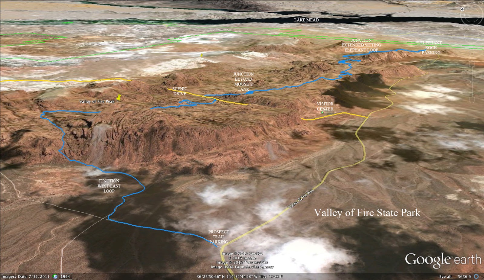
East / West Traverse
(Valley of Fire State Park)
East / West Traverse - This 8.5 mile point to point traverse of the Valley of Fire State Park has an elevation gain of 2000 feet and a loss of 1800 feet. There is a lot of tough scrambling but the adventure is worth the strenuous effort. For more information, contact Brian Dodd (briandodd (at) cox.net).
Echo Canyon
(Red Rock Canyon NCA)

Echo Canyon - The starting point for this hike is located at the Cowboy Trails trailhead on Highway 159 less than one mile west of the Red Rock entrance. The moderate hike is generally done as a loop. There are only short sections of trail in the canyon, with most of the terrain requiring rock scrambling. The best way to return to the starting point is on a trail that leads back to Fossil Ridge. There are two exits from the canyon, so the total distance for the loop hike will range from 4 to 5 miles. Maximum elevation gain will be 900 feet.
Echo Canyon / Fossil Ridge (4 miles)
Echo Canyon / First Finger / Fossil Ridge (6 miles)
Ejection Seat Ridge
(Lake Mead NRA)
Ejection Seat Ridge - This moderate hike begins at mile marker 14.5 on Northshore Road. It drops into a wash before climbing a ridge up to a plateau. There is (or used to be) the remains of an ejection seat used in an airplane crash that happened nearby. The remains of the crash are found in a wash further into the hike. The route is 4 miles with 600 feet of elevation gain.
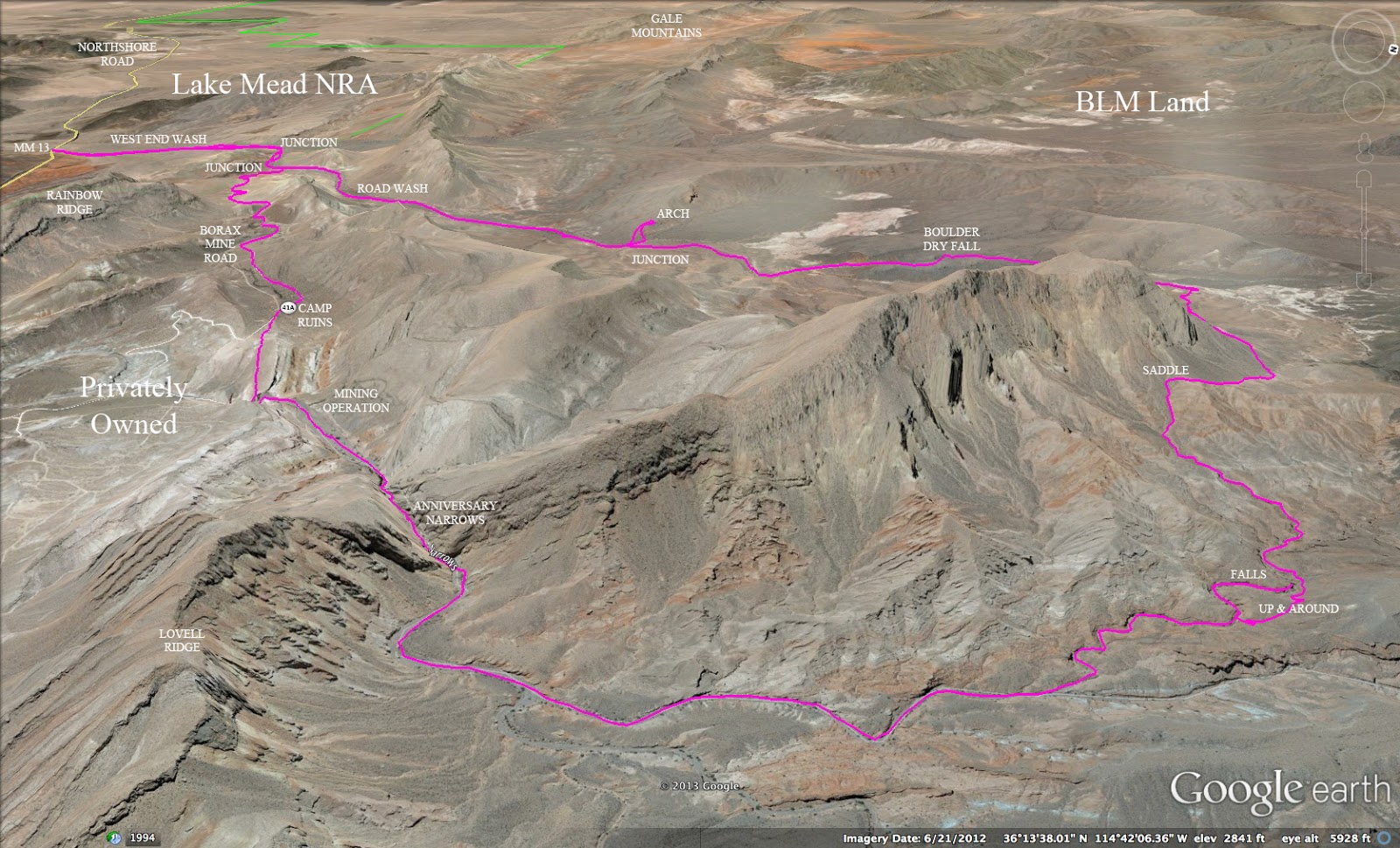
End Around Loop
(Lake Mead NRA)
End Around Loop - At this time, this hike cannot be done as a loop since it involves a section that goes through the private property of a mining operation at the Anniversary Narrows location. It is still viable as an out and back hike beginning at the West End Wash turnout at mile marker 13 on Northshore Road. The route uses the West End Wash to loop around and come in at the top of Anniversary Narrows. Then the route uses an old mining road to complete the loop. As a strenuous loop hike, it is 12 miles with 1600 feet of elevation gain.
Escarpment Base Trail
(Red Rock Canyon NCA)
 |
| The Red Rock Canyon NCA escarpment shown in a rare snowfall (2008). |
Escarpment Base Trail - This trail follows the escarpment on the west side of Red Rock Canyon, going along the base of the cliffs. It is usually a moderate point to point hike that requires spotting vehicles at the destination. It is easier to do the hike from the south, starting at the Oak Creek trail head just past Mile Marker 12 on the scenic loop. All or parts of four trails are combined for the hike, starting with the Arnight Trail, then in succession part of the Pine Creek Trail, all of Dale's Trail, and all of the SMYC Trail. Total distance is 5.6 miles with 470 feet of elevation gain. There are a few short sections of rock scrambling as the trails cross drainages coming off the escarpment. An option for a distance hike would be to begin at the scenic loop exit trailhead and hike out and back to Lost Creek connecting with the Arnight Trail using a use trail across the desert. This moderately strenuous out and back alternative is 13 miles with 1800 feet of elevation gain.
Route from Oak Creek to Lost Creek
Extended Version Out and Back
Escarpment of Kyle Canyon
(Spring Mountains NRA)
Escarpment of Kyle Canyon - This is an easy to moderate 4 mile hike that begins at the Spring Mountains Gateway Visitor Center on Kyle Canyon Road. The trail afford fantastic views of Charleston Peak and Kyle Canyon. There is one hill to climb to get to the top of the escarpment which accounts for half of the 850 feet of elevation gain. Then watch the views unfold.
Escarpment Rim Loop
(Red Rock Canyon NCA)
Escarpment Rim Loop - This strenuous hike has a length of 10 miles with 2200 feet of elevation gain. The route begins at the Mountain Springs Summit Pass Trailhead and hikes to the top of Mountain Springs Peak. From there, it follows the escarpment rim until it reaches a trail that leads down along a wash and across the foothills back to Mountain Springs.


 Echo Canyon - The starting point for this hike is located at the Cowboy Trails trailhead on Highway 159 less than one mile west of the Red Rock entrance. The moderate hike is generally done as a loop. There are only short sections of trail in the canyon, with most of the terrain requiring rock scrambling. The best way to return to the starting point is on a trail that leads back to Fossil Ridge. There are two exits from the canyon, so the total distance for the loop hike will range from 4 to 5 miles. Maximum elevation gain will be 900 feet.