Gass Peak
(Desert National Wildlife Refuge)
Gass Peak - Gass Peak offers an excellent view of the city because of its elevation and proximity to the urban area. The trailhead is located on a rarely maintained road off Mormon Springs Road past the Desert National Wildlife Refuge Visitor Center. The 7-mile out-and-back hike climbs 2000 feet as it follows the eastern ridge to the summit, which houses air traffic control instruments along with solar panels to power the array. High clearance vehicles are a must to get to the starting point, and 4-wheel drive is highly recommended.
Goatbed Peak
(Red Rock Canyon NCA)
Goatbed Peak - This peak borders Gateway Canyon on the north side. It is climbed from the east ridge and descended on the south west side. It is a strenuous scramble of 4 miles with 1200 feet of elevation gain. The hike begins and ends at the Sandstone Drive dirt parking lot. There are a few variations to the general route.
Gold Butte
(Gold Butte, Nevada - BLM Land)
Gold Butte - The area north of the old town site of Gold Butte, Nevada and south of Virgin Peak is filled with beautifully colored and interestingly shaped sandstone. The area was once used by ancient native Americans as is evidenced by many petroglyph sites. Exit off of Interstate 15 at Riverside / Bunkerville (#112), go east for 3 miles then turn right after crossing the Virgin River. Gold Butte Road takes the adventurer twenty miles before reaching a graded dirt road where the fun begins. This is an area with no services and few visitors. Use caution while travelling in this area. Although at present, this is BLM Land with few restrictions, however, it is hopeful that it will soon be designated as a National Conservation Area. There are two hikes listed on this site for the Gold Butte Area: Grand Gold Butte Petroglyph Hike and Little Finland & The Subway.
Gold Strike Canyon (aka Nevada Hot Springs)
(Lake Mead NRA)
Gold Strike Canyon Hot Springs - Also known as the Nevada Hot Springs, the hike follows a canyon to the Colorado River just downstream from Hoover Dam. The trail head is located off a gravel road after turning right at the Hoover Dam exit of Hwy 93. The route follows the drainage, descending over several minor waterfalls as it makes its way toward a sizeable area of hot spring fed pools. Total distance on the out-and-back hike to the pools is 5 miles with 800 feet of elevation gain on the return. The stretch of canyon past the pools going to the river is significantly more difficult with ropes included in the scrambles.
Grand Circle Trail
(Red Rock Canyon NCA)
Grand Circle Trail - The longest hike within the confines of Red Rock Canyon at just over 11 miles, the Grand Circle Trail provides sweeping views of the entire canyon area. Best done as a clockwise loop from the Visitor Center, the trail heads almost directly toward Willow Springs for the first 4 miles before crossing the scenic loop and joining the White Rock Hills Trail. From that point, the trail heads in a southeasterly direction until it reaches Sandstone Quarry. The final 3 miles of the hike are the most scenic, as the trail follows the western side of the colorful Calico Hills before returning to the Visitor Center. Total elevation gain is only about 800 feet.
Grand Circle Hike Clockwise
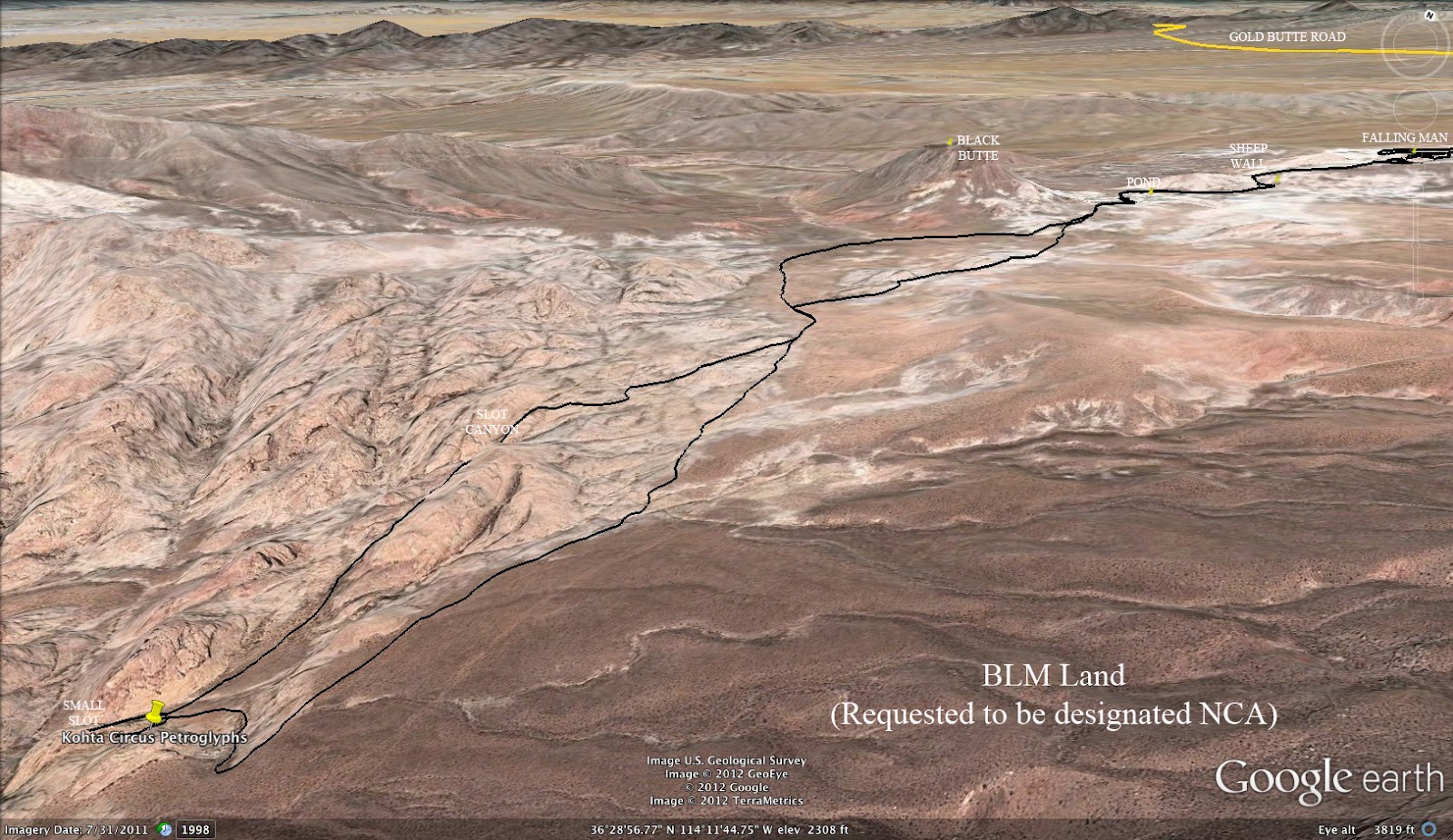
Grand Gold Butte Petroglyph Hike
(Gold Butte, NV)
Grand
Gold Butte Petroglyph Hike - This moderately strenuous route begins at the Falling Man
parking corral and takes the hiker past several petroglyph sites, past
an old dammed pond area and across the desert to the Kohta Circus Site,
the largest panel of petroglyphs found in Clark County, Nevada. It is 7.5 miles with 1200 feet of elevation gain. There is a small amount of scrambling and no exposure on the route.
Grapevine Spring of Kyle Canyon
(Red Rock Canyon NCA)
Grapevine Spring of Kyle Canyon - Starting from the Twilight Trailhead located 9 miles up Kyle Canyon Road, this moderate desert hike travels across the lower Sonoran terrain on the Twilight Zone bike trail and circles around a distant ridge to find the spring. A grapevine swirls at the site and wildlife visit often. The hike is 7.5 miles with 800 feet of elevation gain as an out and back.
Gray Cap Peak
(Red Rock Canyon NCA)

Gray Cap Peak - Gray Cap Peak can be accessed a number of ways. Sandstone Quarry (scenic loop) and the Sandstone Drive gravel trailhead are the most popular. The majority of the hike involves off-trail rock scrambling. The out-and-back route from Sandstone Quarry is 6 miles long, and involves hiking in upper Gateway Canyon to the sandstone area at the top of the canyon. Beyond that point, the hike is all boulder scrambling with no visible trail. Total elevation gain is about 1500 feet.
Traditional Out and Back Route
Gray Cap Loop
Griffith Peak
(Spring Mountains NRA)

Griffith Peak - There are three different routes to the third highest official peak in the Spring Mountains, all of them involving a hike distance of 10 miles. The traditional route is out-and-back along the South Loop Trail to the peak and climbs 3400 feet. The second route is an out-and-back from the end of Harris Springs Road, which requires high clearance vehicles over a rough mountainous road to get to the trail head. This version climbs 2600 feet. The third option is a loop from the top of the community of Rainbow that climbs through Rainbow Canyon and up the Harris Springs Trail before returning on South Loop and a minor trail back to Rainbow Canyon. This route climbs 3600 feet and is the most strenuous.
Ten Mile Loop up Rainbow Canyon (Trail CLOSED due to 2013 Fire)
Nine Mile Out and Back via South Loop (OPEN)


 Gray Cap Peak - Gray Cap Peak can be accessed a number of ways. Sandstone Quarry (scenic loop) and the Sandstone Drive gravel trailhead are the most popular. The majority of the hike involves off-trail rock scrambling. The out-and-back route from Sandstone Quarry is 6 miles long, and involves hiking in upper Gateway Canyon to the sandstone area at the top of the canyon. Beyond that point, the hike is all boulder scrambling with no visible trail. Total elevation gain is about 1500 feet.


 Griffith Peak - There are three different routes to the third highest official peak in the Spring Mountains, all of them involving a hike distance of 10 miles. The traditional route is out-and-back along the South Loop Trail to the peak and climbs 3400 feet. The second route is an out-and-back from the end of Harris Springs Road, which requires high clearance vehicles over a rough mountainous road to get to the trail head. This version climbs 2600 feet. The third option is a loop from the top of the community of Rainbow that climbs through Rainbow Canyon and up the Harris Springs Trail before returning on South Loop and a minor trail back to Rainbow Canyon. This route climbs 3600 feet and is the most strenuous.


