Fern Canyon
(Red Rock Canyon NCA)
(Red Rock Canyon NCA)
 Fern Canyon - The localized name for the North Fork of Pine Creek Canyon gets its name because the abundance of water and limitation of sunlight in the canyon provides the right climate for ferns to grow. This moderately strenuous out-and-back hike is only about 5.5 miles in total distance with 900 feet of elevation gain, but provides some fairly intense boulder scrambling for the participants the farther they get back into the canyon. The turn around point is a dry fall wall upon which hikers can climb atop. The scenery here is awesome.

Fern Canyon Overlook
(Red Rock Canyon NCA)


First Creek
(Red Rock Canyon NCA)
(Red Rock Canyon NCA)


First / Corkscrew Canyons Loop
(Desert National Wildlife Refuge)


Five Mesas
(Valley of Fire State Park)


Fletcher Canyon
(Spring Mountains NRA)
(Spring Mountains NRA)


Fletcher Peak
(Spring Mountains NRA)
(Spring Mountains NRA)
 Fletcher Peak - This is the easiest peak to climb in the upper elevations of the Spring Mountains. A moderately strenuous out-and-back hike of 7 miles, this trek uses the North Loop Trail from the eastern trail head located on Highway 158. The trail climbs to an open meadow area and past a series of twelve switchbacks before reaching the top of a ridge with the peak in view across Hummingbird Gulch. It then follows the ridge for nearly 1/2 mile to a spur trail on the left that goes to the peak. This trail generally stays close to the edge overlooking Kyle Canyon. Total distance for the out-and-back hike is 7.5 miles with 2500 feet of elevation gain. An alternate route starts at a trailhead near Robber's Roost on Highway 158. This route, which is slightly shorter but more strenuous and has some exposure, climbs through Hummingbird Gulch.
Fletcher Peak (North Loop / Wild Horse Canyon)


Fletcher Peak (Hummingbird Gulch O&B)


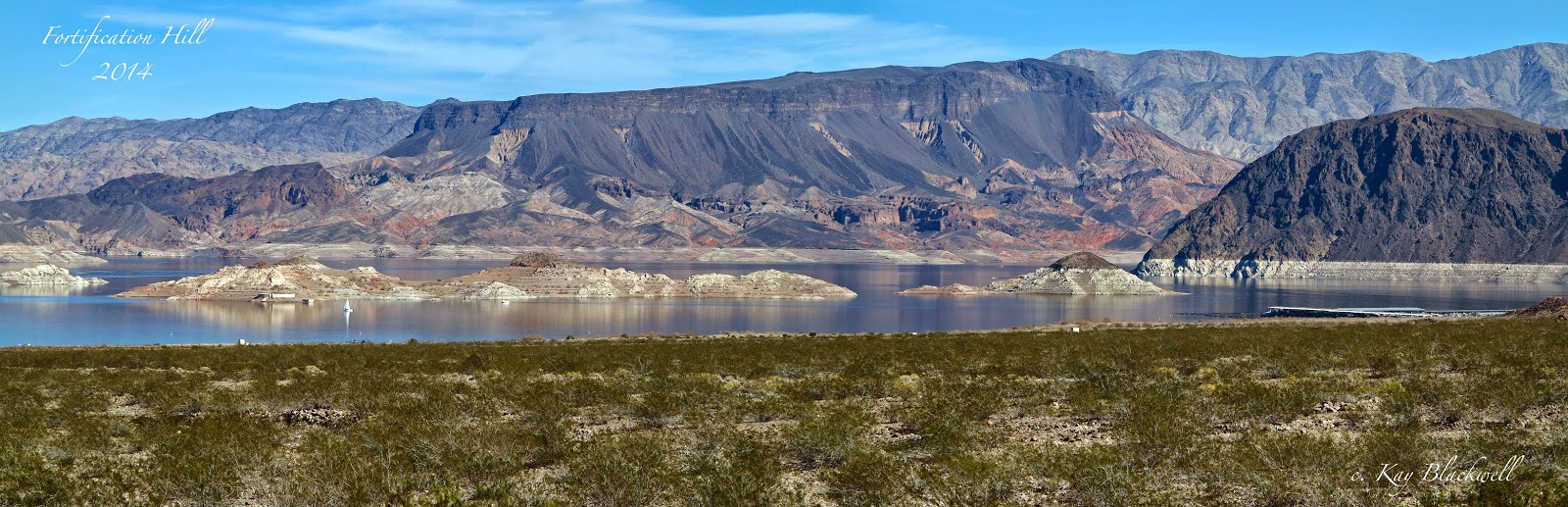
Fortification Hill
(Lake Mead NRA)
(Lake Mead NRA)


Fossil Ridge
(Red Rock Canyon NCA)
(Red Rock Canyon NCA)
 Fossil Ridge - This hike is located on North Blue Diamond Hill across from Red Rock Canyon and starts from the Cowboy Trails trailhead about one mile beyond the scenic loop entrance. It is done as an easy to moderate loop hike, with one leg on the ridge (Fossil Ridge) above Echo Canyon. There are several options available for this hike, starting with an easy to moderate 2.8-mile loop with 400 feet of elevation gain and building that to a moderate 5 mile loop with 750 feet of gain. In any case, part of the hike will pass along the ridge directly above Echo Canyon and with great views down into the heart of the canyon.
Four Burros Loop
(Red Rock Canyon NCA)


Fracture Ridge Peak
(Henderson)
(Henderson)
 Fracture Ridge Peak - The strenuous hike to Fracture Ridge uses the same trailhead and first mile of trail as the hike to Black Mountain in Henderson. At a signed trail split, the Fracture Ridge trail goes to the right and crosses a very wide drainage area before getting to the base of the ridge. The opening part of the climb is very steep, followed by a more moderate ascent on the trail along the ridge. About 1/2 mile from the peak, the trail ends and it becomes necessary to scramble over and around lava boulders and outcroppings. The peak is narrow and offers a great 360 degree view. After descending from the main ridge, another trail passes through the Sloan Canyon Conservation Area before returning to the start. Total distance is 7 miles with about 2000 feet of elevation gain.

Frenchman Mountain - Mt. Reagan
(Las Vegas - East valley - Sunrise Mountains)
(Las Vegas - East valley - Sunrise Mountains)
 Frenchman Mountain - The starting point for the strenuous out-and-back hike is located at the east end of Bonanza Road. An unmarked trail starts as a gravel road and travels somewhat north around a ridge at the base of the mountain. The trail is fairly easy to follow as it climbs alongside a canyon. About halfway up the mountain the trail essentially ends and the route becomes a scramble up a rocky ridge. Periodically, short sections of trail will appear, but the route continues up the ridge to the peak. The main peak is located just south of the communications towers at the top. Care must be exercised on the return because of some exposed outcroppings. Total distance is 4 to 5 miles with over 2000 feet gain.
West Side Canyon Ascent Route

