Painted Pinnacles / Baseline Mesa / Silica Dome
(Valley of Fire State Park)
Painted Pinnacles / Baseline Mesa / Silica Dome - Although there is a shorter hike to the Painted Pinnacles, it requires a 4WD drive to the north side of Baseline Mesa. This nice 5 mile moderately strenuous loop has an elevation gain of 1000 feet. It begins at the Silica Dome TH and makes its way to the colorful sandstone formation then climbs up to the top of the large landmark mesa. From there, a visit to the old picnic site and down into a fun small wash to return. The hike is punctuated with a climb up to the top of Silica Dome. For further information regarding hikes in Valley of Fire, contact Brian Dodd (briandodd (at) cox.net)
Peak 3844
(Red Rock Canyon NCA)
Peak 3844 - This small easy peak is located in the Calico Basin area between Kraft Mountain and Highway 159. The trailhead is found at the wash that crosses the Calico Basin Road 0.4 miles from the Highway 159 junction. The peak can be hiked as an out and back on several different trails but a loop that eventually circles around the summit ridge is more interesting with 4 miles and 650 elevation feet gained. Views of the whole of Red Rock Canyon are seen as the loop is hiked.
Pine Cone Canyon Loop
(Spring Mountains NRA)
Pine Cone Canyon Loop - Pine Cone Canyon is one route between the Bonanza Trail
and the Lower Bristlecone Trail. One loop ascends the steep canyon and turns left on the Bonanza Trail. At the Bristlecone Trail, turn right for a 6 mile loop or left for a slightly shorter loop. If a right turn is made on the Bonanza Trail, a 5 mile loop can be made via South Sister Saddle. The first moderately strenuous 6 mile loop has 1400 feet of elevation gain.
Pine Creek & Fire Ecology Trail
(Red Rock Canyon NCA)

Pine Creek & Fire Ecology Trail - The trailhead for this easy hike is located at the Pine Creek pull-off about 10.7 miles along the Red Rock scenic loop. The trail starts down a long grade, then turns toward the canyon. On the way is a short detour onto the Fire Ecology Trail, which goes back to the drainage where a controlled burn occurred in 1992. The main trail passes the foundation for the old Wilson Homestead, which was occupied in the 1930's. From that point, a short loop goes into the junction of the north and south forks of Pine Creek Canyon. Total distance is between 2 and 4 miles, depending on the side trips taken. The elevation gain is mostly on the return hill to the parking lot.
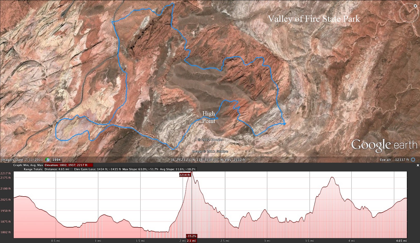
 Pinnacles (Drop Slot)
(Valley of Fire State Park)
Pinnacles (Drop Slot)
(Valley of Fire State Park)
Pinnacles (Drop Slot) - This interesting scramble winds itself over to a slot canyon that requires friction, fun and faith to slide through. Afterwards, the hike continues to a colorful section of the park where rock formations jut up into the air in unison. The moderate loop begins at parking turnout #3 and is 4 miles with 800 feet of elevation gain. For further information regarding hikes in Valley of Fire, contact Brian Dodd (briandodd (at) cox.net)
Pinto Ridge to Jean's Peak
(Lake Mead NRA)
Pinto Ridge to Jean's Peak - This is a moderately strenuous 6 mile point to point hike that begins at mile marker 22 on Northshore Road and ends at mile marker 25. The route gains the ridge up a small wash and on to the peak marked by an old wooden post and cairns. The ridge is negotiable to the northwest with gradual descent until reaching the Jean's Peak climb. After this peak, the route descends into a canyon that exits at the end point. There is a formidable 1900 feet of elevation gain throughout the hike.
Pinto Valley
(Lake Mead NRA)
Pinto Valley - A 11.5 mile point to point hike along an interesting section of the old Arrowhead Highway has endpoints at mile markers 18 and 25 on Northshore Road. The long day's route passes springs, petroglyphs and an old cowboy camp with views of the wide Pinto Valley end to end. Hamblin Mountain can be seen at one end of the valley and Redstone marks the other end. The moderately strenuous hike has around 1200 feet of elevation gain.
Pinto Valley Wash
(Lake Mead NRA)

Pinto Valley Wash - Hamblin Mountain and Pinto Valley Wash share the same trail head just beyond Mile Marker 18 on Northshore Road, about 15 miles from the intersection with Lake Mead Boulevard. The trail begins traveling up the wash toward Lake Mead and then continues up this same wash after the 15-foot dry waterfall is negotiated or a trail around the waterfall is taken. The wash and surrounding area is full of color and interesting rock formations and the wash, parts of which are the old Arrowhead Highway, can be taken as far as you wish to hike. It is an easy to moderate out-and-back hike with 500 to 800 feet of elevation gain.
Potato Knoll
(Red Rock Canyon NCA)

Potato Knoll - The easiest place to access a trail that goes to Potato Knoll is at the gravel parking lot on Highway 159 at the Red Rock scenic loop exit. The partial loop hike starts on a horse trail by the exit gate and heads toward the Oak Creek drainage. After crossing the drainage, the trail loops around the hill which is also known as Wilson's Pimple. Potato Knoll can be climbed easiest from the back side. On the return, the trail crosses Oak Creek three more times, and two of the crossings are often over flowing water. The easy or moderate hike distances is between 4.7 and 5.5 miles, with a vertical gain of 665 feet if the hill is climbed.
Potosi Alcove
(Red Rock Canyon NCA)
Potosi Alcove - The starting point is found by driving
west on Highway 160 about 6 miles from the intersection with Highway
159, then turning left and driving about 0.7 miles on a gravel road to a
small parking area on the left. Or, for a shorter version, the high clearance road heading into the foothills can be driven up to a road junction. Either way, the hike leads into the 3rd canyon from Highway 160 of Mt. Potosi. After dropping into the wash, there is a trail turn to the right about 1/3 mile up. This trail climbs steeply to a very large natural alcove that rock climbers use to hone their skills. The moderately strenuous short version of the hike is 3.5 miles with 1500 feet of elevation gain. Add about 3 miles if you wish to hike the road out and back.
Pueblo Park
(Las Vegas - Summerlin)
Pueblo Park - A former Las Vegas city park, now maintained by the Summerlin Council, Pueblo Park is located just west of the intersection of Lake Mead Boulevard and Buffalo. The entrance is on the north side of Lake Mead Blvd. The 1.5 mile paved walkway goes between the starting point and Rampart to the west. The urban route follows an arroyo that can be full of water during heavy rainfalls. There are many interesting things to see along the way, including a wide variety of plants and some wildlife. As an out-and-back hike, the total distance is 3 miles with minimal elevation change.
Pumpkin Parfait
(Lake Mead NRA)
Pumpkin Parfait Canyon - Located up Northshore Road at the mile marker 40 trailhead (Rogers Spring), this canyon is a colorful hike with seabed fossils, petrified wood and canyon scrambling to entertain. The red, orange and gold sandstone found embedded in the outer limestone layer resembles its namesake. The route ascends to the color then descends through a neighboring wash with more interesting dry falls. The moderately strenuous partial loop is 6 miles with around 1000 feet of elevation gain.


 Pinto Valley Wash - Hamblin Mountain and Pinto Valley Wash share the same trail head just beyond Mile Marker 18 on Northshore Road, about 15 miles from the intersection with Lake Mead Boulevard. The trail begins traveling up the wash toward Lake Mead and then continues up this same wash after the 15-foot dry waterfall is negotiated or a trail around the waterfall is taken. The wash and surrounding area is full of color and interesting rock formations and the wash, parts of which are the old Arrowhead Highway, can be taken as far as you wish to hike. It is an easy to moderate out-and-back hike with 500 to 800 feet of elevation gain.

 Potato Knoll - The easiest place to access a trail that goes to Potato Knoll is at the gravel parking lot on Highway 159 at the Red Rock scenic loop exit. The partial loop hike starts on a horse trail by the exit gate and heads toward the Oak Creek drainage. After crossing the drainage, the trail loops around the hill which is also known as Wilson's Pimple. Potato Knoll can be climbed easiest from the back side. On the return, the trail crosses Oak Creek three more times, and two of the crossings are often over flowing water. The easy or moderate hike distances is between 4.7 and 5.5 miles, with a vertical gain of 665 feet if the hill is climbed.


